


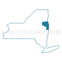
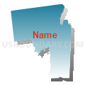
Warren & Washington Counties PUMA, New York
About
Outline

Summary
| Unique Area Identifier | 193493 |
| Name | Warren & Washington Counties PUMA |
| State | New York |
| Area (square miles) | 1,777.49 |
| Land Area (square miles) | 1,698.14 |
| Water Area (square miles) | 79.36 |
| % of Land Area | 95.54 |
| % of Water Area | 4.46 |
| Latitude of the Internal Point | 43.44045000 |
| Longtitude of the Internal Point | -73.63675680 |
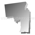
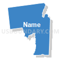
Maps

Graphs
Select a template below for downloading or customizing gragh for Warren & Washington Counties PUMA, New York


Neighbors
Neighoring Public Use Microdata Area (by Name) Neighboring Public Use Microdata Area on the Map
- Clinton, Franklin, Essex & Hamilton Counties PUMA, NY
- Rensselaer County--Troy City PUMA, NY
- Saratoga County (Outer) PUMA, NY
- Southwest Vermont--Rutland, Bennington & Addison Counties PUMA, VT
Top 10 Neighboring County (by Population) Neighboring County on the Map
- Saratoga County, NY (219,607)
- Rensselaer County, NY (159,429)
- Warren County, NY (65,707)
- Washington County, NY (63,216)
- Rutland County, VT (61,642)
- Essex County, NY (39,370)
- Bennington County, VT (37,125)
- Addison County, VT (36,821)
- Hamilton County, NY (4,836)
Top 10 Neighboring County Subdivision (by Population) Neighboring County Subdivision on the Map
- Queensbury town, Warren County, NY (27,901)
- Moreau town, Saratoga County, NY (14,728)
- Glens Falls city, Warren County, NY (14,700)
- Kingsbury town, Washington County, NY (12,671)
- Stillwater town, Saratoga County, NY (8,287)
- Schaghticoke town, Rensselaer County, NY (7,679)
- Hoosick town, Rensselaer County, NY (6,924)
- Granville town, Washington County, NY (6,669)
- Corinth town, Saratoga County, NY (6,531)
- Fort Edward town, Washington County, NY (6,371)
Top 10 Neighboring Place (by Population) Neighboring Place on the Map
- Glens Falls city, NY (14,700)
- Glens Falls North CDP, NY (8,443)
- Hudson Falls village, NY (7,281)
- West Glens Falls CDP, NY (7,071)
- South Glens Falls village, NY (3,518)
- Fort Edward village, NY (3,375)
- Warrensburg CDP, NY (3,103)
- Whitehall village, NY (2,614)
- Corinth village, NY (2,559)
- Granville village, NY (2,543)
Top 10 Neighboring Elementary School District (by Population) Neighboring Elementary School District on the Map
- Shaftsbury School District, VT (2,853)
- Fair Haven School District, VT (2,734)
- Mettawee Community Union School District 47, VT (2,191)
- Orwell School District, VT (1,250)
- Wells School District, VT (1,150)
- Benson School District, VT (1,056)
- West Haven School District, VT (264)
Top 10 Neighboring Secondary School District (by Population) Neighboring Secondary School District on the Map
- Mount Anthony Union High School District 14, VT (23,305)
- Fair Haven Union High School District 16, VT (10,727)
- Pawlet School District, VT (1,477)
- Rupert School District, VT (714)
Top 10 Neighboring Unified School District (by Population) Neighboring Unified School District on the Map
- Queensbury Union Free School District, NY (22,046)
- South Glens Falls Central School District, NY (19,546)
- Hudson Falls Central School District, NY (15,389)
- Glens Falls City School District, NY (15,095)
- Schuylerville Central School District, NY (9,881)
- Hoosick Falls Central School District, NY (7,967)
- Granville Central School District, NY (7,638)
- Corinth Central School District, NY (7,576)
- Stillwater Central School District, NY (7,444)
- Greenwich Central School District, NY (6,686)
Top 10 Neighboring State Legislative District Lower Chamber (by Population) Neighboring State Legislative District Lower Chamber on the Map
- Assembly District 112, NY (139,495)
- Assembly District 113, NY (135,737)
- Assembly District 108, NY (131,716)
- Rutland-2 State House District, VT (8,421)
- Addison-Rutland-1 State House District, VT (3,990)
- Rutland-8 State House District, VT (3,988)
- Bennington-5 State House District, VT (3,776)
- Bennington-3 State House District, VT (3,598)
- Rutland-1-1 State House District, VT (3,524)
Top 10 Neighboring State Legislative District Upper Chamber (by Population) Neighboring State Legislative District Upper Chamber on the Map
- State Senate District 43, NY (322,103)
- State Senate District 44, NY (317,410)
- State Senate District 45, NY (306,856)
- Rutland State Senate District, VT (57,676)
- Addison State Senate District, VT (40,787)
- Bennington State Senate District, VT (39,001)
Top 10 Neighboring 111th Congressional District (by Population) Neighboring 111th Congressional District on the Map
- Congressional District 20, NY (683,198)
- Congressional District 23, NY (664,245)
- Congressional District (at Large), VT (625,741)
Top 10 Neighboring Census Tract (by Population) Neighboring Census Tract on the Map
- Census Tract 708, Warren County, NY (7,387)
- Census Tract 840, Washington County, NY (6,669)
- Census Tract 620, Saratoga County, NY (6,618)
- Census Tract 880, Washington County, NY (6,371)
- Census Tract 601.01, Saratoga County, NY (6,199)
- Census Tract 810, Washington County, NY (6,190)
- Census Tract 518, Rensselaer County, NY (5,735)
- Census Tract 706.01, Warren County, NY (5,701)
- Census Tract 803, Washington County, NY (5,390)
- Census Tract 9609, Addison County, VT (5,337)
Top 10 Neighboring 5-Digit ZIP Code Tabulation Area (by Population) Neighboring 5-Digit ZIP Code Tabulation Area on the Map
- 12804, NY (26,540)
- 12831, NY (17,416)
- 12801, NY (14,707)
- 12839, NY (13,588)
- 12828, NY (9,448)
- 12803, NY (7,567)
- 12832, NY (7,106)
- 12834, NY (6,594)
- 12090, NY (6,262)
- 12822, NY (6,200)